|
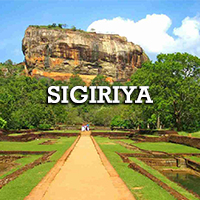
 Sigiriya or Sinhagiri is an ancient rock fortress located in the
northern Matale District near the town of Dambulla in the
Central Province, Sri Lanka. The name refers to a site of
historical and archaeological significance that is dominated by
a massive column of rock nearly 200 metres (660 ft) high.
According to the ancient Sri Lankan chronicle the Culavamsa,
this site was selected by King Kasyapa (477 – 495 CE) for his
new capital. He built his palace on the top of this rock and
decorated its sides with colourful frescoes. On a small plateau
about halfway up the side of this rock he built a gateway in the
form of an enormous lion. The name of this place is derived from
this structure —Sīhāgiri, the Lion Rock. The capital and the
royal palace was abandoned after the king's death. It was used
as a Buddhist monastery until the 14th century. Sigiriya or Sinhagiri is an ancient rock fortress located in the
northern Matale District near the town of Dambulla in the
Central Province, Sri Lanka. The name refers to a site of
historical and archaeological significance that is dominated by
a massive column of rock nearly 200 metres (660 ft) high.
According to the ancient Sri Lankan chronicle the Culavamsa,
this site was selected by King Kasyapa (477 – 495 CE) for his
new capital. He built his palace on the top of this rock and
decorated its sides with colourful frescoes. On a small plateau
about halfway up the side of this rock he built a gateway in the
form of an enormous lion. The name of this place is derived from
this structure —Sīhāgiri, the Lion Rock. The capital and the
royal palace was abandoned after the king's death. It was used
as a Buddhist monastery until the 14th century.
Sigiriya today is a UNESCO listed World Heritage Site. It is one
of the best preserved examples of ancient urban planning.
Sigiriya is considered to be one of the most important urban
planning sites of the first millennium, and the site plan is
considered very elaborate and imaginative. The plan combined
concepts of symmetry and asymmetry to intentionally interlock
the man-made geometrical and natural forms of the surroundings.
On the west side of the rock lies a park for the royals, laid
out on a symmetrical plan; the park contains water-retaining
structures, including sophisticated surface/subsurface hydraulic
systems, some of which are working today. The south contains a
man-made reservoir; these were extensively used from the
previous capital of the dry zone of Sri Lanka. Five gates were
placed at entrances. The more elaborate western gate is thought
to have been reserved for the royals.
Ref:
Wikipedia
|